
Buildings and Architecture
Standing Stones
September 2014
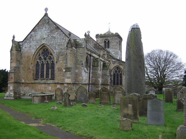
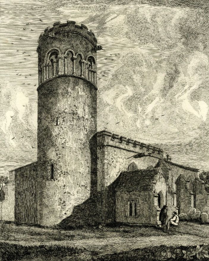
Rudston Monolith and All Saints Church
© J Thomas. Licensed for reuse under this Creative Commons CC-BY-SA-2.0 license via Geograph
There is something about standing stones that is strangely captivating. Their peculiar, ambiguous form draws your attention first; the way that many menhirs – an alternative name that translates as ‘long stone’ in Cornish or Breton – appear as isolated, accusing fingers that do little but point at the sky lends them an air of mystery. Then there is the extravagant effort required to quarry, transport and erect them when our ancestors must have had other calls on their time. Finally there is the question of purpose. Are they ancient memorials, avatars of the ancestors still at large in the landscape or did they have a more prosaic function?
One thing is sure, whatever it was that drove Britain’s various megalithic cultures, it is entirely lost to us now and we might have to make do with the patina of mystique that remains, along with the consolation that visiting our most interesting stones inevitably leads us to some corners of Britain that are interesting in their own right.
Whatever the stones were for, they were certainly part of a wider landscape upon which our ancestors saw fit to erect stone circles, dolmen, barrows, avenues and other pieces of Neolithic or Bronze Age funerary field furniture. In a few cases, they are found in a small group of other stones that form rows or odd arrangements and for which there is frequently a legend attached.
One of the most bizarre arrangements of stones is at the Mên-an-Tol on Penwith in Cornwall – a holed stone, about a metre high, is aligned between two short standing stones, almost certainly not in their original positions. It’s thought to be part of a former circle with the holed stone probably a part of a long-forgotten nearby tomb, but in its rearranged form it is associated with a treasury of miracles, from healing rickets to magical fertility rites.
At Rudston in the East Riding of Yorkshire, the Devil was supposed to have thrown a stone at the church and missed, but Rudston Monolith was here long before the church and at 7.6m (25 feet) high – Britain’s tallest – and 40 tons in weight, it easily matches its younger cousin in terms of gravitas.
Scotland’s tallest, Clach-an-Truiseil – the Stone of Compassion – a stone’s throw from the northwestern coast of Lewis in the Western Isles, stands at 5.8m (19 feet) and is meant, like many menhirs, to signify the site of a battle, although it’s actually the sole surviving monolith from a complete circle, of which there are no shortage on Lewis. Although it now stands alone, its original purpose was surely about making a connection – one that has endured between its builders and the landscape for 5000 years.
Comments
A Moving Tale: Roadside Crosses
August 2014
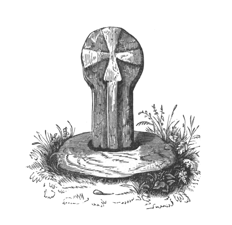
Boswarthen Cross, Madron. From Ancient Crosses and Other Antiquities in the West of Cornwall John Thomas Blight 1856
If you’re off on your summer holidays soon, it’s likely that you are not only getting ready for a long journey to the beach, airport or woodland cottage of your dreams, but also preparing for the familiar chorus of ‘are we there yet’ from the back seat. Passing on Robert Louis Stevenson’s adage that it’s “better to travel than arrive” to children is all very well but, despite his interest in pirates, Stevenson never had to drive the family down to Cornwall in a hatchback.
Long trips feel shorter for everyone when the sights and sounds distract from the monoculture of asphalt and white lines. Instead of just commuting to your holiday this year, why not investigate the road and the romantic tales of travel it offers. Indeed, a variety of monuments erected as waymarks, memorials or commemorations of epic voyages of the past can be found in Britain’s verges.
Most of them take the form of the roadside cross which, in Britain, are distributed north and west of the Jurassic line that runs from Dorset to the Tees and marks where upland and lowland meet. A few crosses crop up to the east of this line on the chalk; one such is Fat Betty – often called White Cross – on the North York Moors just south of the Castleton to Rosedale road. Betty has a square, squat base that carries a tiny round head on which the cross itself is inscribed. She also serves as a boundary marker and like much ancient roadside furniture, there is a story attached which links her to other nearby stones and crosses.
Elsewhere, crosses like Boswarthen, near Madron in Cornwall, are sometimes used to mark a route of pilgrimage. Boswarthen stands close to the path that leads to Madron Well, where ‘clooties’ of cloth hang from the trees, slowly rotting away – so the legend has it – as the well’s waters heal the sick.
A set of elaborately decorated crosses adorn the route of a medieval funeral cortege between Lincoln and London. These are the Eleanor crosses; twelve were originally erected in wood between 1291 and 1294, but were later replaced in stone. They mark the twelve day journey of the body of Eleanor of Castile, the wife of King Edward I – each cross was erected at a place where the Queen’s body rested for the night. Of the twelve, only three remain – at Geddington and Hardingstone in Northamptonshire and Waltham Cross in Hertfordshire. A Victorian replica of the original Charing Cross – destroyed by Parliamentarian forces in 1647 – now stands in the forecourt of the railway station named in its honour. As Stevenson would say himself: “Travel for travel’s sake. The great affair is to move.”
The Churchyard
June 2014
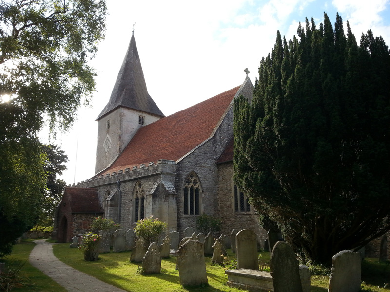
© 2014 Ian Vince | Bosham Church, West Sussex
The American poet and historian Abba Gould Woolson once wrote that, ‘since all this loveliness cannot be Heaven, I know in my heart it is June’. You can’t help wondering how she might have felt in a churchyard this month, where the occupants are theologically, metaphorically and ecologically in both kinds of Paradise at once; a garden of early summer, earthly delights where the veil between the worlds – as on St John’s Eve, later in the month – is tantalisingly thin.
The Litten, or God’s Acre – and it averages out at around an acre for each of Britain’s 23,000 or so churchyards – is evidently not just a quiet place for the dearly departed, but a grassland habitat full of life. Yellow meadow ants build their nests among the gravestones, bees and butterflies appreciate the wildflowers as do moths like the beautiful five-spot burnet and birds sing from the yew and holly trees. They are here because the churchyard has a kind of permanence and has typically been managed with a light touch for hundreds of years since its foundation. Often the history of the plot is deeper; a few ancient graveyard yews even pre-date Christianity in Britain.
Our reverence for churchyards has helped in their conservation, but that’s not to say that they haven’t changed over the years or been subject to the same whims that have informed the spires, battlements, porches, architectural noodlings and decoration on the churches themselves. The foundation of a Christian place of worship in the first place was the most profound of these changes and may have taken place on already sacred ground – a round churchyard may indicate a pagan site, as would large sarsens in the stonework or menhirs close by.
Churchyards were often a lot less peaceful in the past; records exist of Saxon ‘moots’ or parliaments convened and markets held and – as seen in the south porch of St Leonard’s in Thorpe, Derbyshire – you might find 14th century notches in the stonework where archers sharpened their arrows for target practise after Sunday service. There might even have been the flurry of pagan Morris dancers, some wrestling or cockfighting going on and the ‘church ale’ a kind of early beer festival in aid of the parish vestry.
Where God’s Acre now appears larger than an acre, the original churchyard can sometimes be traced by a subtle rise in ground level or by searching for the oldest headstones – until the 1700s they were inscribed on their ‘backs’ – to determine the extent. The churchyard would normally, though not always, have less space on the north side, where the ne’er-do-wells and criminals were buried, forever resting in shadow, even on a bright June day.
Medieval Bridges
March 2014
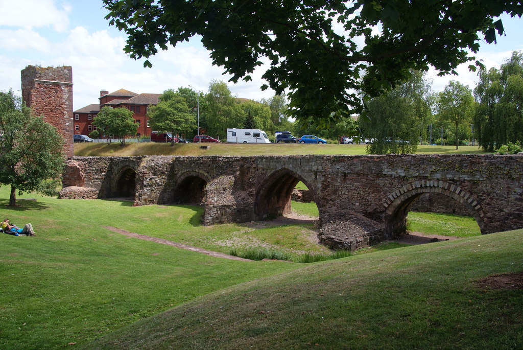
The Old Exe Bridge at Exeter © Copyright Bill Boaden and licensed for reuse under this Creative Commons Licence.
In March our rivers and streams are often in spate, swollen by winter rainfall, aquifers filled to capacity or meltwater from the mountains, so it’s the perfect time to reflect on some of the historic bridges that span Britain’s natural waterways.
From the packhorse bridge’s low parapets designed to accommodate the groaning panniers of ponies en passage, to the pointed cutwaters protecting the piers of medieval bridges, the imperative to connect one bank to another has inspired centuries of development, engineering and even a dash of the evangelical. Indeed, the architecture that tied two banks of a river was second only to the buildings that promised man passage over the ultimate threshold; the medieval period was the golden age of both church and bridge building.
The correlation of passage to another kind of ‘other side’ wasn’t lost on the medieval church and a few bridge chapels still remain – at St Ives, Cambs.,Wakefield, Rotherham and Bradford-on-Avon (though re-purposed as a town gaol) – all of which underline the spiritual importance of stone bridges in the landscape. In Durham, bridge building was the direct responsibility of the bishop but it was only one of many medieval cities where bridges had a connection with the cathedral.
Like churches, the high status of bridges ensured that they were periodically improved and occasionally re-built for the needs of the day; just as cathedrals are rarely the work of a single architectural period, it’s not uncommon to find bridges exhibiting building styles that span hundreds of years, all of which can make dating them difficult. Fortunately, a few reliable indicators to age such as the shape of the arches and the presence of ribbed vaults will help you sort out original or, at least, faithfully restored features from later modifications. At Exeter, the disused and now incomplete 13th century Exe Bridge has latterly been run aground and stranded on a traffic island, but at least you don’t have to get your feet wet to admire its fabulous ribbed arches alternating between Norman-inspired semicircular and the pointed arches which were the invention of Early English church builders. By the 1500s, the segmental arch – round but less than semicircular – enabled longer spans, useful in upland locations where flood waters could sweep away a bridge with too many piers. Two of the three spans of the Devil’s Bridge, Kirkby Lonsdale, Cumbria are in excess of 16 metres, while Twizel Bridge in Northumberland has a single span of approximately 30 metres.
We may take them for granted, but medieval bridges reveal our history; engineering feats first pulled off high above the mumble of prayers have found a way of helping us all over troubled waters.
Stone Walls
January 2014
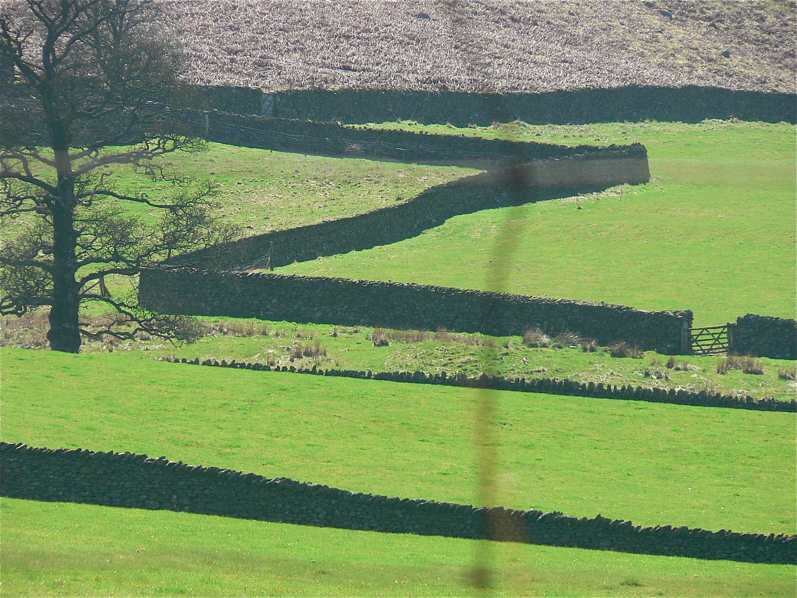
Like many areas of upland Britain, carns and quoits, tumuli, standing stones and a host of other familiar megalithic field furniture dominates the commons of West Penwith – the Lands End peninsula – but there’s one ancient artefact that barely gets a look-in, the landscape itself.
From the downs above Zennor and Boswednack, this landscape appears as an assembled patchwork; panels of pasture and meadows, an irregular hotchpotch of small enclosures sewn together by the seams of dry stone walls known locally as ‘Cornish hedges’, many of which boast a Bronze Age origin – archaeology recovered from the field walls themselves confirms that they are the oldest working artefacts in the world.
Nobody is quite sure, but there are thought to be around 125,000 miles of dry stone wall in Britain, mainly in upland areas north and west of the Tees-Exe line, where hedges don’t survive well, but also where the materials to build them are freely available. Construction is demanding.
A shallow foundation is dug – between 70 and 90cm wide – and large stones that can take the load of the wall are laid in this trench, the faces of the wall, which tapers towards the top ‘coping stones’ where it will be just 30cm wide, are laid next and the core is filled with looser rubble. At periodic intervals, a course of ‘through stones’ ties the two sides together.
It takes around two tonnes of stone to build every metre of wall and, ideally, all of that should come from the field that the wall is in. In that way, at least, every wall not only forms part of the landscape but is also formed by the landscape, so much so that the dedicated landscape reader can deduce rich detail about local geology simply by looking at a wall.
Not only local geology, but ownership as well – if a wall is over five feet, it’s probably a boundary as well as a field wall – while the march of walls across the landscape is also a chronicle of our relationship with the land. In Anglo-Saxon times, for instance, agriculture was concentrated in the lowlands where it was more successful with the techniques of the day and it wasn’t until the twelfth century enclosures of the Cistercians that dry stone walling made a come-back – indeed you can still see medieval field walls at Fountains Abbey in North Yorkshire.
The history of dry stone walls is also the history of the enclosures that started in the fifteenth and lasted until the nineteenth century; the story of the agricultural invasion of the uplands, culminating in the Parliamentary Enclosures of the eighteenth century when swathes of moorland commons were walled off to graze sheep.
Winter Solstice
December 2013
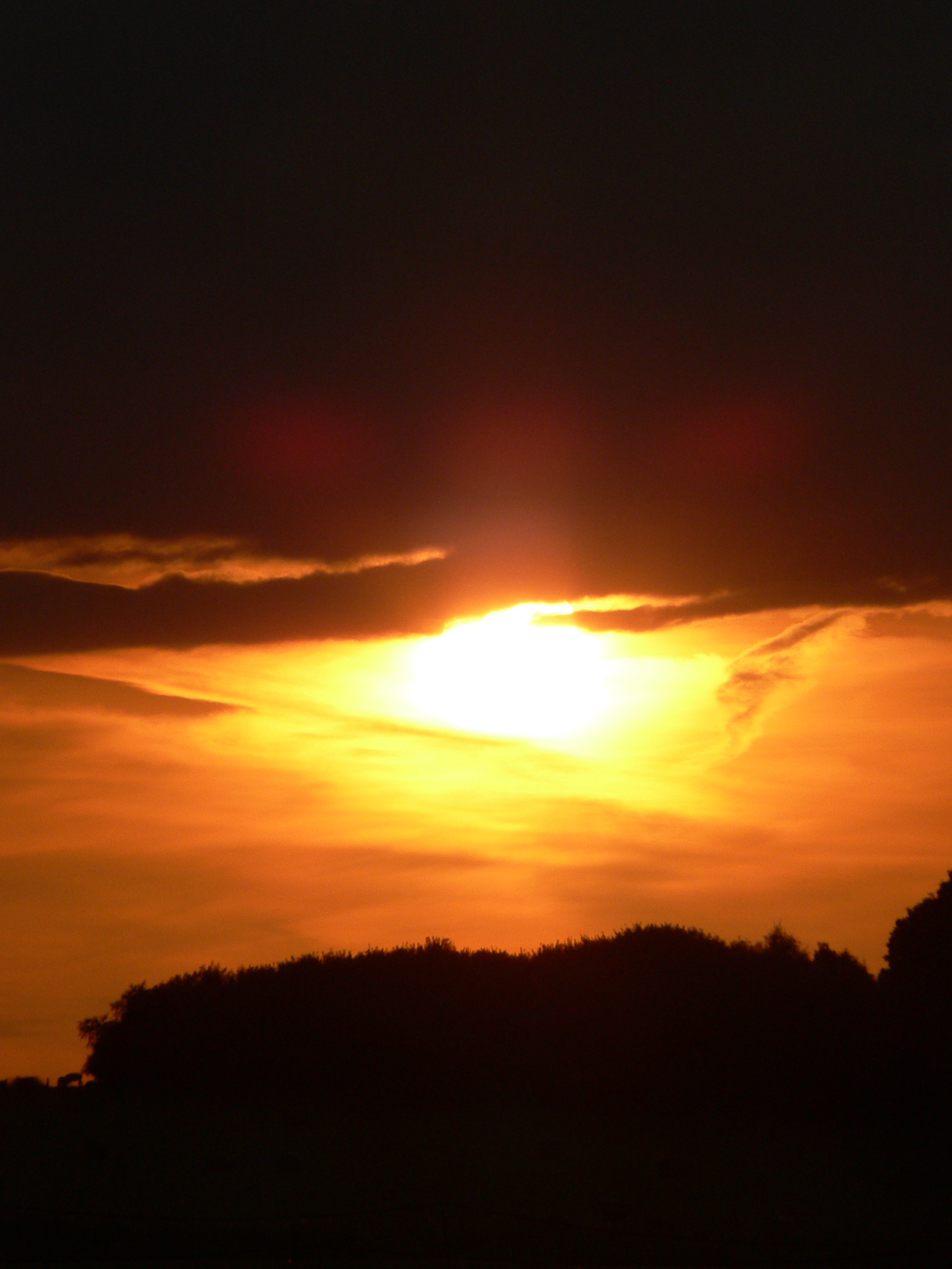
Film buffs know that a walk into the sunset signifies some kind of closure – perhaps a happy ending, a turning point or new start – but it’s not just Hollywood, the same significance is also loaded into one particular sunset, the turning point of the year, the winter solstice.
While crowds of 20,000 routinely descend on Stonehenge every year for the summer solstice, partying through the night to avoid having to get up early, far fewer make it to witness the winter event, which is odd because many proven solar alignments are nothing to do with blazing June at all, but everything to do with deepest December.
Away from Stonehenge, there’s no better place to get clues on what to look for than in Britain’s other great Neolithic landscape, Orkney. The chambered tomb of Maes Howe offers the definitive winter solstice experience when light from the sunset streams down a 14.5 metre-long passageway to illuminate the back wall of the tomb. On the shortest day, it slips below the horizon directly behind the Barnhouse Stone menhir to the south-southwest. At the nearby Ring of Brodgar and Stones of Stenness, the sun lodges itself into the notches of distant hills, underlining the importance of marking the day with accuracy.
Further south on Cranborne Chase, the Dorset Cursus – a mysterious 10km-long neolithic structure now mostly ploughed out, but once bounded by great parallel banks and ditches – follows a solstitial line that links neolithic barrows along its course. The funerary aspect of the route which, if the later association of Bronze Age barrows is anything to go by, seems to have been honoured for centuries after its construction, have marked out the Dorset – and other – cursuses for consideration as processional walkways of some kind.
There are thousands of stone circles, menhirs and other ancient monuments scattered across Britain and investigating your local prehistory with a search for solstice gold can be the satisfying culmination of a midwinter walk. What’s more, there’s none of the inconvenience of an early rise and you only have to be out and about in the late afternoon. It’s a great time to investigate solar alignments on the ground, to see the world a little as our ancestors did and to discover a familiar landscape anew. With the right conditions and a bit of luck, you may even uncover an ancient, forgotten midwinter alignment last noted thousands of years ago in the neolithic or Bronze Age.
Back at Stonehenge, I’ll be walking up The Avenue at just the right moment to create a DIY CGI effect and witness the sun setting behind Stonehenge ‘rising’ over the brow of the hill. Pure Hollywood and a fitting finish to the year.
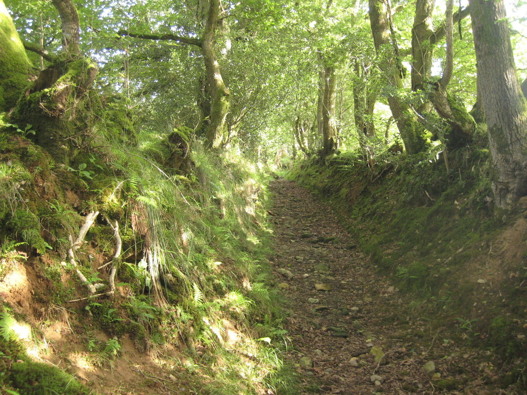
Holloways and Green Lanes
November 2013
Of all the various roads and paths that snake their way through the countryside – A roads, B roads, byways and bridleways – it’s interesting to note that some ways are invested with a little more romance than the rest and by some ways, I mean green lanes and holloways.
While ‘green lane’ is a catch-all for many different kinds of unsurfaced rural road or path – such as an old drove, a coffin road or a ridgeway – a holloway is a more specific term. It describes a sunken green lane, a track which was been worn down by the passage of thousands of feet, cartwheels and hooves over hundreds of years, even millennia. With the loosened soil subsequently washed away by the next downpour, the course of a holloway will often become more pronounced on the side of a hill because of the extra energy imparted by the surface water run-off.
Holloways are common in lowland Britain with the greensands of the southern counties – Wiltshire, the Weald and the Chilterns – being particularly suited for their formation, as is the old red sandstone of the Wye and Usk valleys of Wales and the Marches, while the new red sandstone of south and east Devon has splendid, deep lanes on its slopes.
Over time, as they are inscribed ever more deeply and the level of the lane lowers, they become more sheltered and trees arch over, creating a womb-like tunnel, an enclosed place of natural safety. So safe, indeed, that it’s only around this time of the year that the walls of foliage have died back enough to get into some old lanes, long-since-abandoned by changing patterns of passage over the land, bypassed in favour of a better route.
Where holloways have fallen into disuse for even longer periods, they can be discovered anew – many centuries after they were last followed – by tell-tale shallow linear grooves through fields or woodland, though check that it’s not a short stretch of long-forgotten park pale or a defensive ditch, both of which will be accompanied by a bank above the natural ground level.
Holloways have their own atmosphere, an unexpected quality which cannot be explained away purely in terms of the local topography or geology. As ancient routes, they are the perfect expressions of collective will, tracks which share a common origin with desire lines – those unpaved paths across city parks or shortcuts over open ground that urban planners never anticipated. As travelling long distances was more difficult in the past, the reasons were more keenly felt; every footstep has meaning on a pilgrimage and the burdens shouldered on a well-used coffin road were more than the purely physical.
Trig Points
October 2013
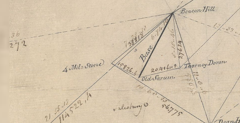
Just northeast of Old Sarum, the abandoned city that looms over younger, yet medieval, Salisbury, lies a monument important enough to be marked on Ordnance Survey maps, along with an intriguing inscription: ‘Gun End of Base’.
In many ways, it’s the most important point on the map, because if it wasn’t for Gun End of Base – actually the muzzle of a cannon buried vertically, business end up – there might not be a map at all. This is the spot where the first definitive mapping survey of Britain began in 1794, where initial measurements for the ‘principal triangulation of Britain’ were taken by Artillery man Captain William Mudge.
You can still see the snout of the cannon at Old Sarum, but the gun at Beacon Hill, 7 miles to the north where Mudge set his theodolite, was eventually replaced by a triangulation pillar, or trig point, 140 years later.
A small, tapered obelisk 4 feet tall and 2 feet square at the base, often found at the summit of a hill, the trig point is a welcome sight for walkers and climbers, although you don’t always need to scramble to the top of a draughty peak to bump into one; starting with Cold Ashby in Northamptonshire – in the middle of a rather flat field at SP644765 – there were around 6,500 built between 1936 and 1960, including one on the Little Ouse in Norfolk TL617897, a metre below sea level. Today, around 5,500 pillars remain at large, though only 110 remain in active service as part of a GPS-style network.
A familiar fixture in the British countryside since the OS built them to survey the country anew, the stability of trig points enabled surveyors to take very accurate measurements which allowed them to perform calculations that, in the trig point’s day, were accurate to 20 metres from one end of Britain to the other. Satellite technology has now improved that to just 3mm.
Trig points aren’t the only mapping artefacts you can discover in the field. Small metal plates marked with a broad arrow pointing up to a horizontal line, or ‘bench mark’, indicate a known height above sea level – and can be found on most pillars as well as the sides of churches, bridges and public buildings. They are joined by around half a million chiselled-out marks on walls all over Britain, which helped to define every last contour and spot height that appear on the map, often next to the triangular symbol that marks the trig point. And, as you catch your breath from the climb up to that pillar, you’ll see that if there’s one thing you can be sure of, it’s a fine view – of the next one.
Deserted Medieval Villages
September 2013
The eternal peril of its pubs and post offices aside, it’s hard not to view the British village as something of an indestructible institution, but it wasn’t always such a permanent fixture and the threats that it faces now pale into insignificance next to the menaces of the middle ages, when entire communities could be smeared from the map on the say-so of just one person.
The ‘Medieval Village’ label on Ordnance Survey maps carries an inevitable presumption of plague, but the spectre of a multitude of whole settlements exterminated by the Black Death is an exaggeration. Conspicuously large churches, like the magnificent St Mary’s at Tunstead in Norfolk where construction work was halted by the Great Mortality (as it was known at the time) are perhaps better indicators of the plague’s effect; villages were certainly weakened and reduced, but they were not always completely extinguished.
The real menace of the middle ages – the agent of chaos that threatened communities up and down the land – turns out to be nothing more than the humble sheep. Innocuous and dim as individuals, in farmed flocks their role as woolly bailiffs was well-established before, and for centuries after, the Black Death left its mark.
Cistercian monks were among the first to farm sheep on the enclosed lands of evicted villages. The Cistercian craving for isolation found expression in the destruction of villages like Cayton and Herleshow in Yorkshire in the twelfth century, both given to Fountains Abbey in return for eternal salvation for their noble freeholders, while tenants suffered the temporal damnation of being forced to move on.
The Black Death would play its own merry part later. With a reduced working population demanding better terms, the manorial lords, perhaps inspired by the Cistercians, filled their lands with sheep. Wharram Percy in the Yorkshire Wolds, the most famous of Britain’s 3,000 abandoned villages, was finally cleared in the early sixteenth century and enclosure continued in England for another three hundred years. From the seventeenth century on, enclosure was increasingly for country house emparkment, where designers like Lancelot ‘Capability’ Brown grazed on the profits of landscape enclosure in place of the sheep.
In Scotland, the ovine menace reared its ugly head once more in the infamous Highland Clearances of the eighteenth and nineteenth centuries. Some of the most brutal of the clearances occurred at Boreraig and Suisnish on the north shore of Loch Eishort on Skye; families were forcibly evicted and sent packing, their homes burnt down. Geologist Archibald Geikie who happened to witness the eviction in 1853 described the cortege that led north along the track from Suisnish and the grief-laden wail echoing along the strath as a ‘prolonged note of desolation’.
Saxon Churches
August 2013
Above: Little Saxham in Suffolk - Most of Britain’s round Saxon church towers are in East Anglia
Church building being what it is – a rather drawn-out process that can occupy an entire generation or two, if not centuries – it’s perhaps no surprise that, nonconformist chapels aside, there are very few churches in Britain built wholly in one discreet architectural style. Given that Anglo-Saxon rule – from the early 5th century to 1066 – ended almost a millennium ago, it seems unreasonable to expect to find very much of their architecture left that hasn’t been substantially ‘improved’ upon or remodelled during the 950 years of fads and fashions that followed. But it is out there, you just have to look for the clues.
The most distinctive architectural indication is the triangular-headed window; where ever you see one, such as those at St Mary’s Deerhurst, four miles down the Severn from Tewkesbury, it’s conclusive evidence of a Saxon church, as is the tower’s herringbone masonry – a feature shown off to staggering effect at St Margaret of Antioch’s in Marton, Lincolnshire. Not all the windows have triangular heads, however, Saxon windows and doors often have rounded arches which can be distinguished from their Norman counterparts by chunkier stonework, particularly the roughly turned supporting pillars or ‘balusters’ which can call to mind over-engineered snooker table legs in their form.
Another strong, though similarly unfussy, detail is the Saxon pilaster, a thin, vertical stone column that bears a resemblance to the timbers found in Tudor vernacular architecture. Together with the string-courses that finish every storey of the tower at Earl’s Barton church in Northamptonshire, the half-timbered Tudor look is striking.
There’s good reason behind the unsubtle – and what many might regard as heavy-set – overtones of the Saxon church; the hammer and chisel didn’t make it into the stonemason’s toolkit until the second half of the 12th century and until that happened, Saxon, as well as early Norman, masons had to craft their stone with a hatchet.
As buildings that have been in continuous use for centuries, all old churches are works in progress and so their architectural features, historically, have always been at the mercy of fashion. There is one Saxon feature, however, that is present in almost every parish church built ever since, the tower. As part of a place of worship the tower is a Saxon invention which has been adopted into British church architecture in a variety of forms. Figuring among the Saxon forms of it are a smattering of rather beautiful round towers – most, like Little Saxham in Suffolk are located in East Anglia. The reason for this concentration of round towers might be geology; the local building stone is flint, which, because of the way it fractures, is very difficult to build corners with.
A Lot of Roman Around
July 2013
Known as Quintilis before Julius Caesar modestly renamed it in his own honour, the month of July is a fitting time to consider one of the most striking features of the British historic landscape, the Roman road. Although there are about 2,000 miles of them shown on Ordnance Survey maps, estimates of the total length of the network, including presumed minor thoroughfares undiscovered and skulking under fields, suburbs and industrial estates across Britain could expand it to around 6,000 miles.
They were built as logistical tools of empire, to move legions and supplies at speed and, it seems in some cases, to scare the willies out of the locals; Ackling Dyke on the chalk upland between Martin Down and Blandford Forum strides out across the landscape on an overstated, six feet high embankment that shows utter contempt for the barrows, dykes and cursus it merrily ploughs through. The bank – or agger – of the road, though exaggerated, is of a typical layered construction; indeed, the latin word for layers, strata, gave us the word street, an Anglo-Saxon place name often found along the course of Roman roads. Stretford, Stratford, Stretton, Street and their ilk are common names of settlements found along the way, while the Norse word for road, ‘gate’ – particularly when used with ‘stone’ or its derivatives Stan, Stane or Stoney – might also indicate the course of a Roman road.
In Europe the maxim holds that ‘all roads lead to Rome’ while in Britain, they tend to radiate from London. The Fosse Way – between Exeter and Lincoln – goes against the grain, however, and may have even started as a defensive structure during the early years of the invasion, then adapted later as a road and an enduring one, to boot; much of it survives as a taut thread of primary and secondary routes through a tangle of English country lanes. Despite their reputation for straightness (between Ilchester and Lincoln, a distance of 180 miles, the Fosse Way never deviates more than 6 miles from the crow’s flight) pragmatism forced Roman architects to make more concessions to the landscape over time and the Roman road eventually learnt how to bend.
Stanegate, which crosses the Pennines south of Hadrian’s Wall between Corbridge on the Tyne and the Solway Firth, is one such winding road. It connects at Corbridge with Dere Street, the most easily traceable Roman route into Scotland, running all the way to the Forth Estuary. Given that there’s evidence of Roman activity as far north as a line from Stirling to near Stonehaven and claims of a fort at Inverness, there are likely to be many more roads found, long-forgotten, on the outskirts of towns or hidden in the remote straths and glens of Caledonia.
Lych Gates
November 2012
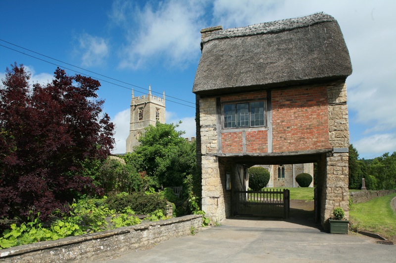
Lych Gate at Long Compton Church, Warwickshire. Photo credit: Hellsgeriatric / Foter.com / CC BY-NC-ND
In a month that starts with All Hallows and All Souls, two opening feast days of November that sift and grade the dearly departed for salvation – first the saints and then the aints – it’s natural to look at the earthly, temporal end of the process. After all, before anybody gets to pray for your soul, there’s the matter of getting into the churchyard in the first place.
Lych gates, which acquired their name from the Saxon word for corpse, stand at the threshold of all thresholds, the entrance to God’s acre. Although many were built before 1549 – Beckenham and Boughton Monchelsea in Kent are dated to the thirteenth and fifteenth centuries, respectively – it became a requirement of the Book of Common Prayer that priests “metyng the corpse at the church style” should commence the service there and that only encouraged construction of lych gates to keep everybody (and every body) dry.
As if hiding their true and gruesome purpose, lych-gates often have a charming gingerbread cottage-cum-chocolate box appeal. They are commonly built from stout timbers and capped by a pleasing and petite doll’s house roof, but the gate at Long Compton church in Warwickshire surpasses all of that to find itself at the peak of picturesque – an entire seventeenth century thatched cottage, minus most of its ground floor, the last surviving of an old row demolished in the 1920s, functions as the churchyard’s gate.
Other designs are grander, the gate at St Peter’s Church, Carmarthen is a vaulted Victorian gothic creation in red sandstone which competes for attention with the lime-rendered tower of Wales’ largest parish church. Sometimes, as at the church of St Germanus, Rame in southeast Cornwall, the gate appears to be a funereal dual carriageway complete with a six-foot long central reservation, the bier or lych stone, to park the deceased on, while benches on either side were provided for the pallbearers, who may have had to walk long distances to church.
Corpse ways to outlying areas of the parish were part of an extensive funereal topography, especially in upland Britain. In Derbyshire, before Coton-in-the-Elms had its own church, bodies were carried a mile and a half along Procession Way to Lullington for burial. The mourners passed under a curve of tree boughs known as the Devil’s Arches on their journey. In Devon, a long-distance footpath – the “Lich Way” – follows a twelve-mile long corpse road over the moor to the church at Lydford and, this being Dartmoor, there are tales of spectral monks walking the trail on moonlit nights.